COURSE MAP
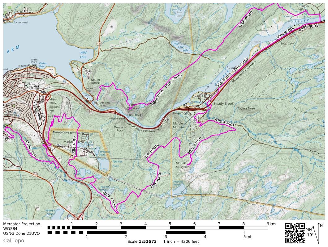
NOTE: The map data on Caltopo "Interactive Map" shows distance/elevation to be slightly short, we’re very certain you’ll cover the full prescribed distance on the day.
RACE DETAILS 50k
Distance: 50.4km, 2169m (7132ft) elevation gain
Cut Off Time: 12 hours, 8PM, Sept 3th
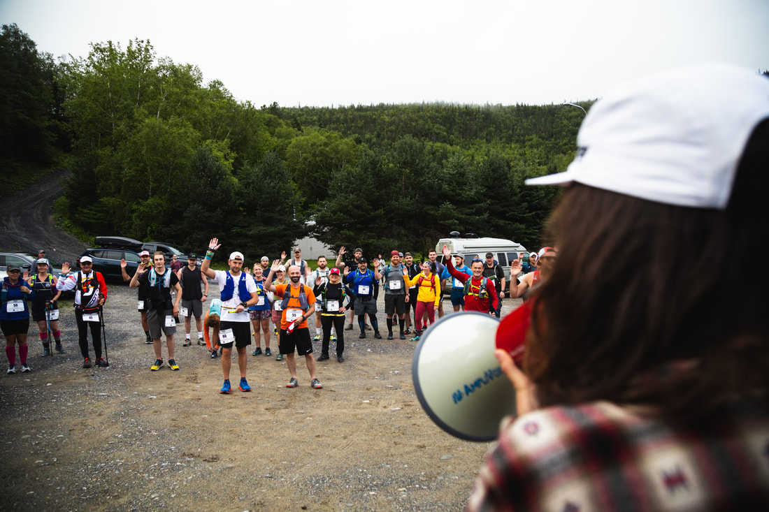
WHEN: 8AM September 3th, 2022
WHERE: Corner Brook, NL
LEG 1
Man in the Mountain to Humber Village
14.2km, 910m elevation gain, single track
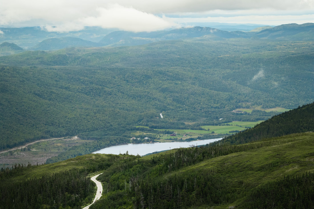
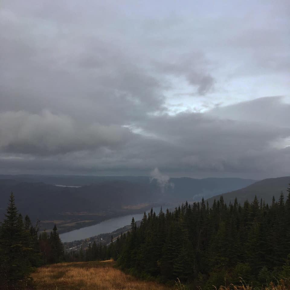
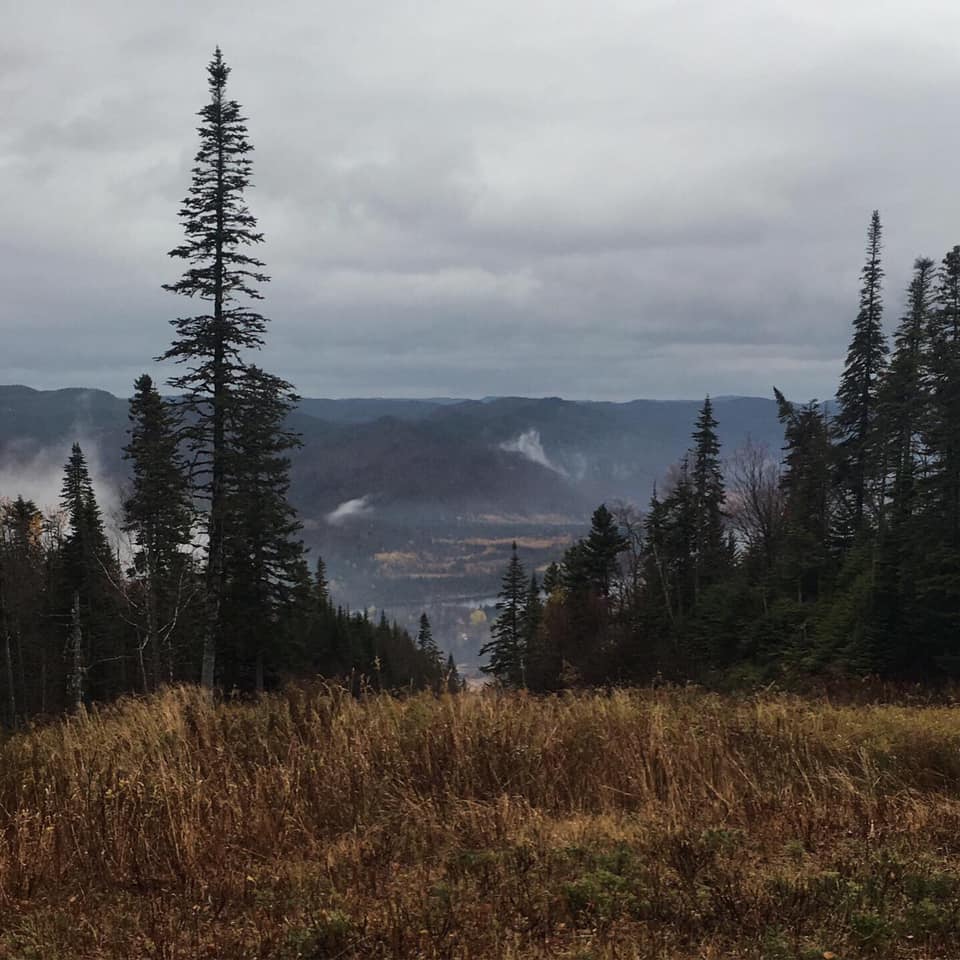
Start steep! Climb 400m from sea level in 2.5 km to the summit of Man in the Mountain. Follow the meandering ridgeline over 3 peaks and deep valleys of the Humber Valley trail. Incredible views of the Humber River Valley. Final decent descends into Humber Village. Run through Humber village untill coming to a no way around it T junction. Our signage will tell you to head left. Run around the backside of Humber Village to the aid station at the community centre!
LEG 2
Humber Village to Marble Mountain
10.1km, 77m elevation gain, gravel road, pavement road and singletrack
Rejoice in the feeling of a flat leg! Cry about all the repetitive pounding your legs are about to experience! Follow a gravel road from Humber Village into Steady Brook, connect with a paved community road for 3km. Head left on to a single track trail in Steady Brook and take in views of the climb up Marble Mountain that you're about to tackle. Cross the river under the bridge, and follow the quad trail to Marble Mountain Aid Station.
LEG 3
Marble Mountain to Massey Drive
14.6 km, 659m elevation gain, singletrack, gravel and double track
Leaving Marble Mountain, you'll take the scenic round the north side of the mountain. You'll climb to the top, and complete a mandatory out and back to the Doppler, the highest point on the course (640m), to get super views of the Blomidon Mountains and Bay of Islands. Head down from the doppler, following signs for "Knute Chute" to "Tuckamore Tangle", feel the burn in your thighs began! You'll run through the forest, cross a usually wet bog and come out at the top of a craggy gulch, before heading back up hill to Massey Drive connector road. Follow the ATV road for 2km, before heading on to the "two pines" mountain bike trail. Follow Two Pines to "Jurassic Park" and then to "Enchanted forest". This trail will spit you out meters from Massey Drive Aid!
Leg 4
Massey Drive to Corner Brook
14.4km, 439m elevation gain, singletrack, quarry road
Head out from the aid station via an ATV trail known as the water supply road. Jump on to "Mikey's" mountain bike trail, and follow it to "Bunny Blaster" take bunny blaster all the way to the sub station road. Once hitting the substation road you will climb back up via the powerline trail to Lakeview drive! head down behind a row of houses, cross the main road, and head to the trails! Descend through the back of Massey Drive, through an old quarry with phenomenal views of where you started! Connect with a series of bike trails that wiggle across ridgelines at the top of Corner Brook. Take in the view of the bay. You're almost there! Descend off of the ridge, and cross a road to connect with the final 4km of trail along the Corner Brook Gorge. You'll start this section with a smooth gravel community trail, before heading into a rugged technical rolling single track, all the way to the finish line!
|
|
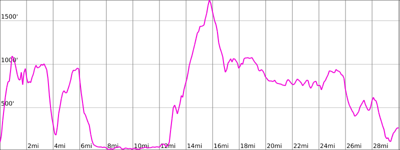
RACE INFO 100k
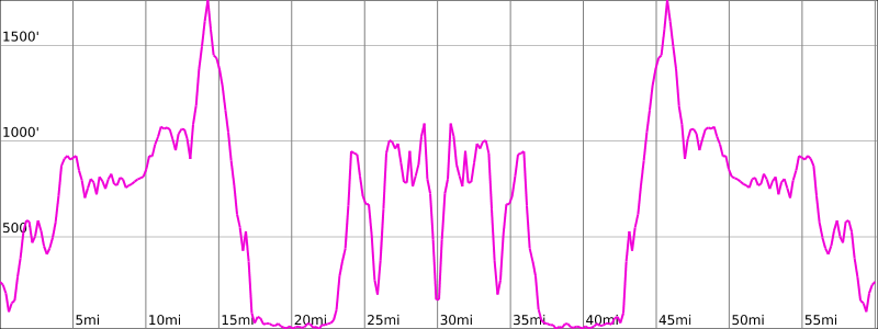
Distance: 101.2 km, 4152m (13,502ft) elevation gain
Cut Off Time: 22 hours, 4AM, Sept 6th
WHEN: 6AM September 5th, 2020
WHERE: Corner Brook, NL
Leg 1
Corner Brook to Massey Drive
14.6km, 627m elevation gain
Start STEEP! Start at Margret Bowater Park and climb through fantastic singletrack bike trails along the river gorge. Cross a road and continue the climb to the top of Corner Brook via the Curry Climb. Take in spectacular views of the bay of islands and Blomidons Mountain Range. Continue thorough an old quarry that has incredible views of the Humber Valley and the ridgeline you'll be traversing later. Once leaving the quarry you'll run through residential road, cross a main road and follow a steep ATV track to the Massey Drive mountain bike trail network. You'll take the Bunny Blaster trail to Mikeys before descending to the water supply ATV track, and crossing to main line to the Massey drive aid!
Leg 2
Massey Drive to Marble Mountain
14.3 km, 657m elevation gain
Leaving Massey Drive, head into 4 kilometers of trails in the enchanted forest, with connecting to jurrasic park, twin pines, and on to the cardio climb access road. You’ll hook into gravel road for a few kilometers (rejoice in the even terrain… but it’s all uphill). Then, you’ll dip on to another powerline for 700 meters before turning off to an old Marble Mountain connector trail. This area is really boggy, but if you stay close to the markers, we've picked the driest path! You’ll flow into Marble mountain on beautiful forested trail, before coming out on the Tuckamore Tangle to see fantastic views of the humber valley. You’ll head up the mountain via the “Twister” and “Knute Chute” ski runs, and you’ll make a mandatory out and back from the Ski Patrol shack to the Doppler (Mount Musgrave Summit). You’ll head down from the Doppler back to the Ski Patrol Shack and take “Country Road” down. Aid Station will be at the bottom.
LEG 3
Marble Mountain to Humber Village
10.1km, 89m elevation gain
Rejoice in the flats! Run from Marble, on atv trail to single track crossing the river to Steady Brook trails, follow those to Humber Village. Climb through the town of Humber Village, to the start of the Humber Valley Trail. Aid Station here.
LEG 4
Humber Village to Man in the Mountain
13.1km, 910m elevation gain
Most grueling section. Climb from sea level to a meandering ridgeline and the deep valleys of the Humber Valley trail. Incredible views of the Humber River Valley. Find yourself overlooking the Bay as you descend steeply to the Man in the Mountain trailhead. You're halfway there!
NOW YOU TURN AROUND AND DO IT ALL AGAIN. ONLY 50.4k AND 7,000ft MORE VERTICAL TO GO!
Leg 5
Man in the Mountain to Humber Village
14.2km, 910m elevation gain, single track
Start steep! Climb 400m from sea level in 2.5 km to the summit of Man in the Mountain. Follow the meandering ridgeline over 3 peaks and deep valleys of the Humber Valley trail. Incredible views of the Humber River Valley. Final decent descends into Humber Village. Run through Humber village untill coming to a no way around it T junction. Our signage will tell you to head left. Run around the backside of Humber Village to the aid station at the community centre!
LEG 6
Humber Village to Marble Mountain
10.1km, 77m elevation gain, gravel road, pavement road and singletrack
Rejoice in the feeling of a flat leg! Cry about all the repetitive pounding your legs are about to experience! Follow a gravel road from Humber Village into Steady Brook, connect with a paved community road for 3km. Head left on to a single track trail in Steady Brook and take in views of the climb up Marble Mountain that you're about to tackle. Cross the river under the bridge, and follow the quad trail to Marble Mountain Aid Station.
LEG 7
Marble Mountain to Massey Drive
14.6 km, 659m elevation gain, singletrack, gravel and double track
Leaving Marble Mountain, you'll take the scenic round the north side of the mountain. You'll climb to the top, and complete a mandatory out and back to the Doppler, the highest point on the course (640m), to get super views of the Blomidon Mountains and Bay of Islands. Head down from the doppler, following signs for "Knute Chute" to "Tuckamore Tangle", feel the burn in your thighs began! You'll run through the forest, cross a usually wet bog and come out at the top of a craggy gulch, before heading back up hill to Massey Drive connector road. Follow the ATV road for 2km, before heading on to the "two pines" mountain bike trail. Follow Two Pines to "Jurassic Park" and then to "Enchanted forest". This trail will spit you out meters from Massey Drive Aid!
Leg 8
Massey Drive to Corner Brook
14.4km, 439m elevation gain, singletrack, quarry road
Head out from the aid station via an ATV trail known as the water supply road. Jump on to "Mikey's" mountain bike trail, and follow it to "Bunny Blaster" take bunny blaster all the way to the sub station road. Once hitting the substation road you will climb back up via the powerline trail to Lakeview drive! head down behind a row of houses, cross the main road, and head to the trails! Descend through the back of Massey Drive, through an old quarry with phenomenal views of where you started! Connect with a series of bike trails that wiggle across ridgelines at the top of Corner Brook. Take in the view of the bay. You're almost there! Descend off of the ridge, and cross a road to connect with the final 4km of trail along the Corner Brook Gorge. You'll start this section with a smooth gravel community trail, before heading into a rugged technical rolling single track, all the way to the finish line!
|
|
|
